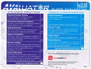
The Avaluator is a decision making tool.
It is a card and guidebook that leads you through gathering information and observations before and during your trip to the mountains.
By being more aware of the predicted and actual stability and weather conditions, and looking at this in conjunction with the type of terrain that you are choosing, the Avaluator will help you to acknowledge a recommended level of caution for your planned venture.
 The Avaluator is a tool for semi-trained backcountry recreationalists. The proper use of this tool is well explained in the accompanying booklet, however it is recognized that the tool is more useful in the hands of a user that has completed the 16 hour AST Level 1 Class and Field program.
CLICK HERE to register for an AST1 classroom session. Zacs Tracs has taught avalanche classes throughout Western Canada and the northern US. Perhaps this season has us teaching somewhere near you?
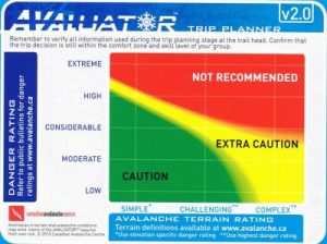
Pre-Trip Planner
The first part of the system is the Pre-Trip Planner.
CLICK HERE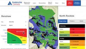 to learn how to use the Avalanche Canada’s Interactive Online Trip Planner which contains officially rated terrain in each of the bulletin areas.
This webpage will walk you through steps to properly use the Avaluator to make decisions from home that compare the current avalanche conditions and your expected terrain choices.
![]() CLICK HERE TO FOLLOW THIS LINK to read the definitions of the Canadian Avalanche Centre Danger Scale.
CLICK HERE TO FOLLOW THIS LINK to read the definitions of the Canadian Avalanche Centre Danger Scale.
CLICK HERE TO FOLLOW THIS LINK to the Avalanche Canada’s Glossary to learn more about the ‘Avalanche Terrain Exposure System’ (ATES) rating system. What exactly is SIMPLE, CHALLENGING and COMPLEX terrain?
These decisions are all related to Trip Planning, before the trip….but what about decisions when you are in the field?
To learn about the Slope Evaluation Card….just CLICK HERE